Advantages
- Users more satisfied
Villagile™ enables real-time monitoring of events in the territory and their resolution thanks to a unified multi-service mapping (reporting, request and interventions) and key indicators. - Centralized and secure data
Villagile™ is based on open source to guarantee the sovereignty and security of your data now valued on a single platform. - A complete and modular SaaS service
Our solution is agnostic and can interface with existing tools and data sources in your territory for centralized management. - Reduce delays and costs
Villagile™ helps coordinate work and allows you to share field information, actions and documents to optimize interventions on the urban space.Users more satisfied
Villagile™ enables real-time monitoring of events in the territory and their resolution thanks to a unified multi-service mapping (reporting, request and interventions) and key indicators. - Centralized and secure data
Villagile™ is based on open source to guarantee the sovereignty and security of your data now valued on a single platform. - A complete and modular SaaS service
Our solution is agnostic and can interface with existing tools and data sources in your territory for centralized management. - Reduce delays and costs
Villagile™ helps coordinate work and allows you to share field information, actions and documents to optimize interventions on the urban space.
Features
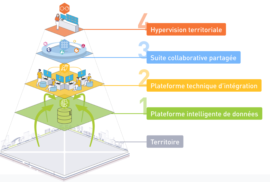
- Intelligent Data Platform
Collects data on services from delegates
Collection of open data on the territory
Identification of events on the territory (urban planning)
Management of reports on the territory (agents, citizens)
Exposure of the territory's data to EPCI and external actors - Integration platform
Manages the directory of agents of the communes and EPCI and the access rights to the information
Integrates secure access to delegatee extranets
Integrates access to community business tools - Shared collaborative suite
Multi-year coordination of work on public spaces
Management of requests between actors: municipalities, EPCI, delegates
Management of reports and relaying to the right actors
Shared document management - Territorial monitoring
Unified mapping of the information related to the activity of the delegates on the territory
Unified mapping of territorial assets
Dashboard of services
Alerts by event detection

Image Generic
Image Generic
References
"The collaborative exchange platform, integrated into the ATLAS 360 dynamic and connected control center, gives us a real-time 360° view of the sanitation department's activity. The centralization and sharing of data at a single point thus guarantees the city control of its sanitation system."
Robert MEDINA, Vice-President of Toulouse Metropole in charge of water and sanitation
Would you like to know more about a solution or get in touch?
Form is loading.
If the form does not load after a few seconds, please reload the page (CTRL + F5 or (or Cmd + Shift + R on Mac).
